Special layer setup
see also: Data layer, Vector layer, Isoline layer
5Back to visualisation start page
The special layer is designed to display singular information in the map like buildings or plants.
Different to the data layer, the value of any information stored on the special layer is a link to a special information.
For example, the value „1" can identify a building on this grid. In order to display this information, you must link this value to a data set which defines the display color and the meaning to the information.
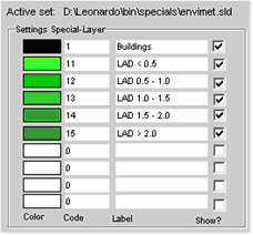
To edit the Special layer settings, open the Settings 2D dialog and press the Special Layer tab.
In the screen shot above you see the default settings when visualising ENVI-met data files.
The special information stored in ENVI-met data files contains information about the buildings and the leaf area density in divided into 6 classes.
You can load the pre-defined dataset for ENVI-met by pressing the "ENVI-met defaults" button.
To show a special in your map, select the "Show Special Layer" option.
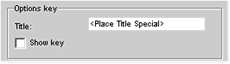
LEONARDO provides a special key (legend) for the special layer.
To include the key in the map, select the "Show key" option.